The Sunlight Foundation has just put Google Earth to an excellent advocacy purpose: letting us follow the (budgetary) money. As the Foundation’s Gabriela Schneider writes:
Mashing up Google Earth and with the companies, universities and nonprofit recipients of earmarks in the House Defense Appropriations bill (available from Sunlight and Taxpayers for Common Sense on EarmarkWatch.org), citizens can get a bird’s eye view of where members of Congress are shipping our defense dollars, and zoom in close on recipients. Each plotted earmark links to a corresponding page on http://EarmarkWatch.org so you can investigate the earmark to determine whether it addresses pressing needs, favors political contributors or is simply pure pork. You can search for earmarks by city, state or zip code.
Now, Google Earth’s just about the most fun online tool to play with (Zoom in! Zoom out! Zoom in! Zoom out! Repeat as necessary), but this is a good example of the serious uses to which it can be put. Earmarks are those little “extras” that congressmembers slip into appropriations bills and are the eternal bane of budget hawks. Since they’re outside the normal budgetary process, publicity is often their worst enemy, and Google Earth really lets you see how they’re distributed in a way that text alone can’t. Let’s look at an example, courtesy of a couple of screen-captures and some Photoshop magic:
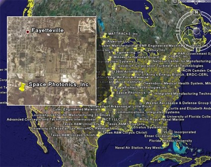
When you drill down, you can see that Space Photonics of Fayetteville, Arkansas appears to be getting $1,000,000 for an Intelligent Free Space Optical Satellite Communications Node — hmmm, sounds like something that might just become self-aware and launch a genocidal war against humankind. More details on the project and how to install it at the Sunlight Foundation blog.
– cpd
[…] The availability of tools like Stimulus.org is a good sign. [One of the first things I am going to do is to mutate the tool in order to make it useful for enterprises to prioritise their projects!]. The very existence of the data in a downloadable form allows for mashups to be created with relative ease, particularly those with geographical overlays, as in this example taken from epolitics: […]