A Powerful (and Frightening) Look at the Disappearing Louisiana Coast
June 21st, 2010
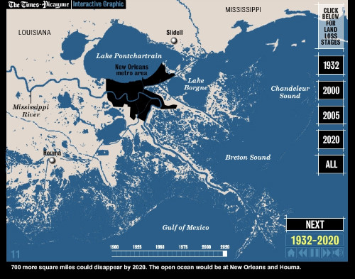
The oil spill may be an ongoing tragedy in the Gulf, but Louisiana’s coast was in danger of disappearing for a long time before the Deepwater Horizon well was a gleam in BP’s eye. For years, a combination of levees on the Mississippi, land subsidence, the extension of a vast network of canals through the coastal wetlands, invasion by non-native species and sea level rise have conspired to sink the state at a rate of a football field’s worth of land lost PER HOUR. How?
Glad you asked, since the staff at the legendary New Orleans Times-Picayune has put together a clear and concise visual explanation of how the Mississippi River created the place we call Louisiana, and how our changes to the river system are destroying it. Check it out, or read more from Epolitics.com about social media and the BP oil spill.
– cpd
Robot-Selected "Related" Articles:
- Tracking the Louisiana Oil Spill’s Effects through Social Media
- What’s Next for Epolitics.com
- The Internet’s Role in the Jena Six Protests in Louisiana
- Google Bans Senatorial Campaign’s Anti-MoveOn.org Ads
- Heading to New Orleans
- Email: As Cool As Spats and Starched Collars
- SXSW Politics Panel Podcast to Top the Pop Charts


Help build e.politics
Make a comment, correct my errors, suggest more tools and tactics, leave a case study, or otherwise make this page a better resource.
Some HTML allowed:
<a href="" title=""> <abbr title=""> <acronym title=""> <b> <blockquote cite=""> <cite> <code> <del datetime=""> <em> <i> <q cite=""> <strike> <strong>
Trackback this post | Subscribe to the comments via RSS Feed